Dr. Tarendra Lakhankar’s research interests are interdisciplinary in nature, but broadly fall into the common theme of exploring the use of remote sensing and geographical information system (GIS) to solve problems in environmental engineering, water resources management, and other civil engineering areas.
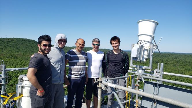
New York Urban Hydro-Meteorological Testbed (NY-uHMT)
Leading the effort to develop Urban Hydro-Meteorological Testbed in New York City, through setting up several weather monitoring stations across the City. The Objective of this testbed will be:
- To develop integrated high-resolution mapping of ground and atmospheric conditions, focusing on the lower atmosphere, to detect and forecast severe wind, tornado, hail, ice, and flash flood hazards,
To improve the accuracy and lead time of measuring and accessing the precipitation and providing Warn-on-flash flood forecasts and warnings in the New York City region, - To create impacts-based, urban-scale flash flood and hazard warnings and forecasts for a range of public and private decision-makers that result in measureable benefit for public safety and the economy,
- To develop collaborative models for federal/municipal/private partnerships for education outreach to NYC schools with on-going interdisciplinary weather system research at NOAA-CREST Center.
Current Students: Candace Agonafir (PhD), Jake Longenecker (MS), Dimitri Ambroise (MS), Leslie Vasquez (BS), Puja Roy (BS)
Graduated Student: Adedoja Adeyeye (MS), Adrian Pena (MS), Erin Wengerter (BS), Kenneth Arguedas (BS), Kiara Roman (BS)
CREST NY-uHMT Website
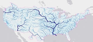
Assessment and Application of National Water Model using Remote Sensing Data Products
An integration of satellite observations into hydrological models is crucial for the future development of the National Weather Service (NWS) operational streamflow and flood forecast system. The National Water Model (NWM) is a hydrologic model that simulates current and forecast streamflow over the entire continental United States (CONUS). This task aims at improved understanding of physical processes represented in NWM and future model development. Under thus task, we will investigate the use of the Weather and Research Forecasting Hydrological modeling system (WRF-Hydro), which is the core of the NWM operated by the NOAA’s National Water Center (NWC), in simulating streamflow and major flood events caused by heavy rainfall and snowmelt. Moreover, we will integrate observations into models for a future/proposed NWS operational forecast system for Puerto Rico to improve flash flood guidance for Puerto Rico. This research would include assessing the efficacy and impacts of atmospheric forcings used to drive the NWM for both wet and dry extreme conditions and in monitoring and prediction to inform drought and flood risk management.
Current Student: Engela Staphit (PhD)
Graduated Student: Anthony Bravo (BS)
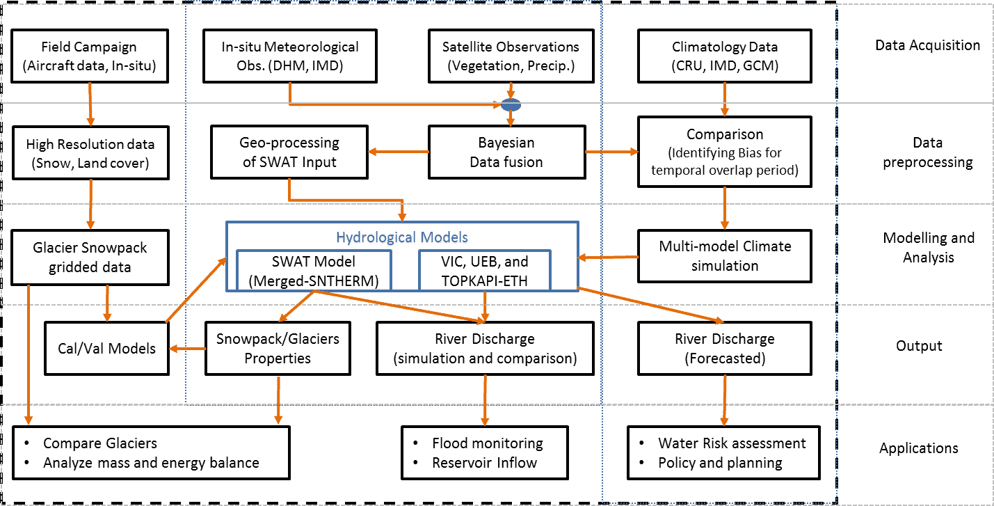
Snow Moeling and Satellite Remote Sensing Data
The CREST-Snow Analysis and Field Experiment (CREST-SAFE) is being carried out using dual polarized microwave (37 and 89 GHz) radiometers along with detailed synchronous observations of snowpack properties with an objective to characterize the behavior of snow-emitted mssssicrowave radiation throughout the winter season. The effect of snowpack temperature (related to dry and wet snow conditions) on the microwave brightness temperature will be examined and interpreted. I am principal investigator of this multi-institutional CREST-SAFE Experiment Website.
- Basic Snow Research (Link Hydrology and Earth System Sciences Paper)
– Field Experiments using Microwave Radiometers (37 and 89 GHz) – Preliminary Analysis
– Algorithm Development for Snow Water Equivalent using Microwave Remote Sensing Data
– Synergistic Use of Remote Sensing for Snow Cover and Snow Water Equivalent Estimation - Applied Snow Research
– Remote Sensing and Ground-Based Weather Forcing Data Analysis for Streamflow Simulation
– Remote Sensing based Snow estimates for Hydrological Models Applications - Calibration and Validation of snow products
– Validation of NOAA Interactive Snow Maps with National Climatic Data Center (NCDC) Data
Graduated Students: Jessica Chiu (BS), Christine Chen (MS), Hiram Sanchez (MS), Jose Infante Corona (PhD), Carlos Perez (PhD) and Jonathan Munoz (PhD)
Assimilation of Remote Sensing Satellite Data in NOAA's Flash Flood Forecasting System
with Student: Dugwon Seo (PhD graduated), and Juan Mejia (MS)
– Evaluation of Operational National Weather Service Gridded Flash Flood Guidance
– Use of microwave soil moisture product to improve FFG System
– Validation of Gridded Flash Flood Guidance System by Statistical Analysis
This study proposed the value of remote sensing data in constraining the state of the system for main-steam and flash flood forecasting. The results from successfully developed technique implied potential improvement of flash flood forecast with SMOS and SMAP satellite sensors assimilation in hydrological modeling.
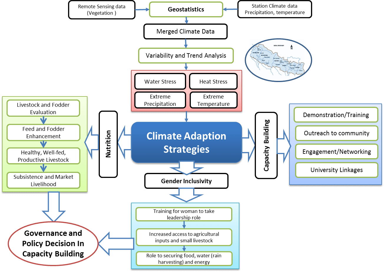
Development of Climate Adaptation Strategy for Agro-livestock Systems in Nepal
- Adaptation for climate change by livestock smallholders in Gandaki river basin inNepal”, USAID Funded
– Spatial and Temporal Variability of Rainfall in the Gandaki River Basin of Nepal Himalaya (publication)
– Development of Probabilistic Precipitation Estimation using Satellite Product
– Recomendations on National Livestock Policy of Nepal: Needs and Opportunities - Field activities (Workshop, stakeholders Meeting)
- Project Presentation to USAID
Remote Sensing of Soil Moisture
Soil Moisture Field Experiment (CREST-SMART)
Student: Laetitia Kumassi (MS graduated), Jonathan Nunez (MS Graduated).
Field experiment is being performed in a grassland at the NOAA-CREST–Soil Moisture Advanced Radiometric Testbed (CREST-SMART) facility, which includes a mobile L-band dual-polarized radiometer with an in situ soil temperature and soil moisture observation network, located near Millbrook, NY. The research investigates changes in the performance of microwave soil moisture retrieval with diurnal soil temperature variations. Dr Lakhankar and CCNY Team participated in NASA field Campaign in carried out in Research facility in Millbrook NY and Harvard Forest, MA.
CREST-SMART Website
Other Documentation links:Link 1,
Ph.D. Research
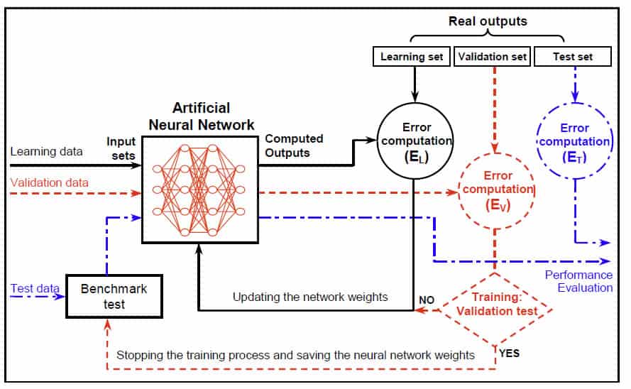
My doctoral research was focused on the application of Neural Network and Fuzzy Logic for retrieval of Soil Moisture using time series of microwave remote sensing data (RADARSAT-1). This study deals with the application of back-propagation neural network and fuzzy logic in estimating the surface soil moisture using Synthetic Aperture Radar (SAR) data and other impacted variables. In addition A multiple linear regression model has also been developed to establish the relationship SAR data and hydrological variables. The potential of SAR images in spatial soil moisture estimation depends on the ability of these algorithms to define the complex relationship that exists between the backscattered energy and the moisture content of the soil.
Other Projects
- Microwave Remote Sensing for Vegetation Monitoring
Student: Doralee Pellot (MS. Graduated in May 2012)
– Evaluation of QuikSCAT Data for Regional Monitoring of
Vegetation Phenology
The objective of this study is to evaluate vegetation phenology data based on VIS/IR monitoring and correlate with corresponding data based on microwave radar remote sensing. The relationship between QuikSCAT backscatter, NDVI and LAI will be analyzed across a wide range of global vegetation types and geographical locations. The NDVI and LAI product from MODIS will be used in this study to understand the effect of seasonality. - Data Assimilation Research
– 4D Variational Data Assimilation Technique for Soil Moisture Estimation.
– NPOESS Soil Moisture Data Assimilation Research using WindSAT Data. - Optical-Microwave (active) synergism for Agricultural and Hydrological application
– A variational assimilation method for soil moisture using active microwave data.
– Developing soil moisture retrieval model and active microwave SAR data.
– Develop adjoints for soil moisture retrieval model and parameterization.IGARSS’08 Abstract - Geostatistical techniques for large scale soil moisture variability
– Generate variogram and kriging maps from in-situ soil moisture data (Sensors link).
– Compare variogram parameters of in-situ && remote sensing moisture data. (AMS 2008 conference Link)
- Soil moisture retrieval using and remote sensing technique (Poster)
- – Soil moisture retrieval using Neural Networks & Fuzzy Logic method. (Journal paper Link)
– Effect of land cover variability on soil moisture retrieval. (Journal paper link)
– Active and passive Microwave remote sensiing for soil moisture. - Application of Geostationary and Polar Orbiting satellite for Assessment of Forest Fire
– Study of NDVI retrieval from MSG SEVIRI data.
– Time series analysis of NDVI for assessment of forest fire risk
– Global NDVI assessment using 2 decades of NOAA-AVHRR satellite data. - Neural Networks algorithm for Snow Cover Identification
– Spatial estimation of snow cover using passive microwave (SSM/I) data.
– Neural Network and filtering algorithm foor mapping snow cover. - Planned, customized and directed GIS projects.
– Directed image processing, and raster-to-vector conversion.
– Enhanced the quality control framework immprove product quality.
– Digital database generation using Ortho-PPhotograph and IKONOS images. - Environmental Impact Assessment
– EIA for an industrial area using Remote Sensing and GIS.
– Prepared technical reports and spreadsheeets for evaluation of projects.